
What is a Cyclone
A cyclone (specifically a tropical cyclone) is a large-scale low-pressure system that forms over warm tropical or subtropical waters, characterised by intense swirling winds, heavy rainfall, and often destructive storm-surge along coastlines. (Wikipedia)
Depending on the region the same phenomenon may be called a hurricane (Atlantic/Eastern Pacific) or typhoon (Western Pacific), but the formation mechanisms are essentially similar.
How Cyclones Are Formed
Here’s a step-by-step overview of the genesis of a tropical cyclone:
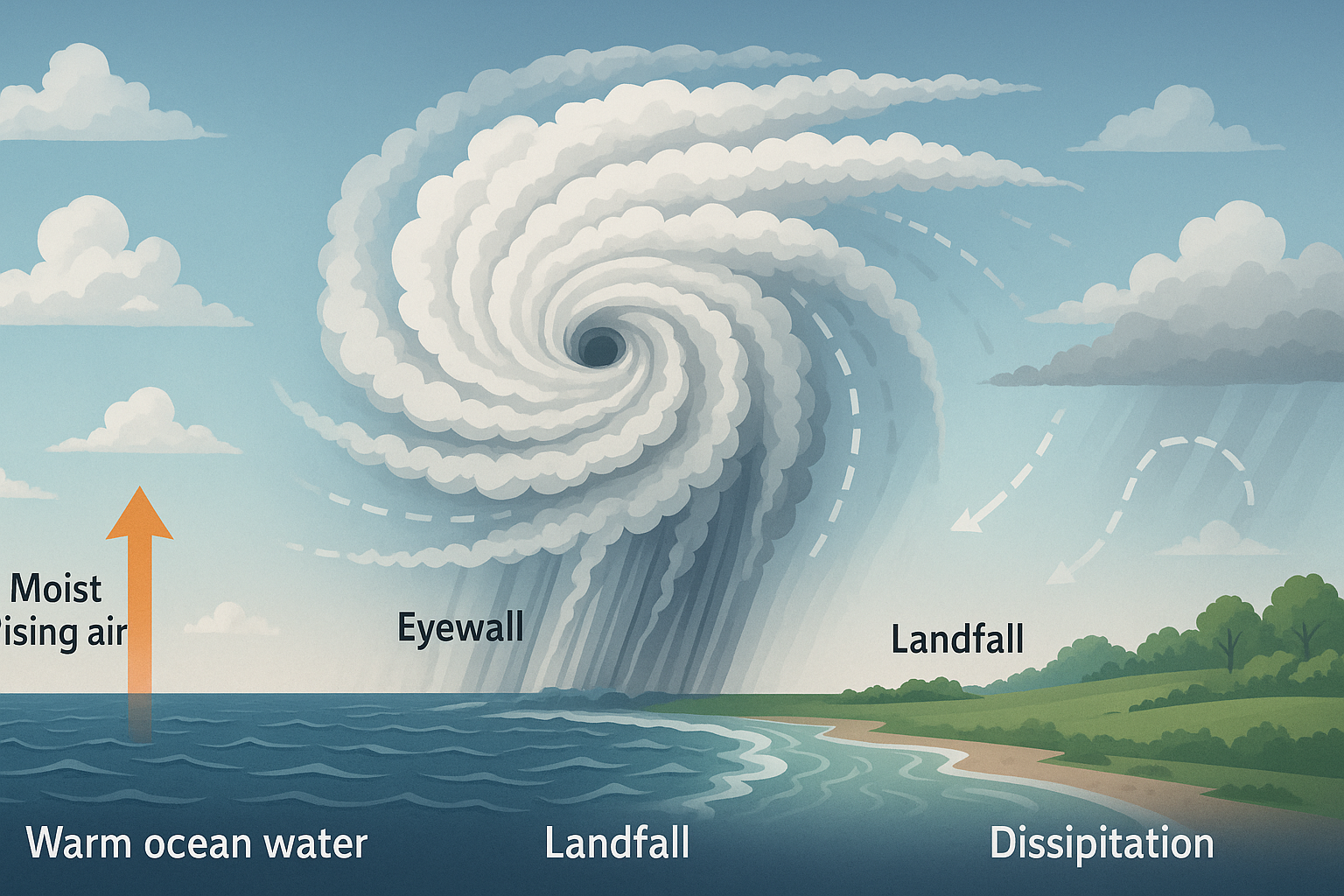
- Warm ocean water → For a tropical cyclone to start, sea surface temperatures typically must exceed ~26 °C (80 °F) to provide enough heat and moisture. (descartesunderwriting.com)
- Evaporation & rising air → Warm, moist air above the ocean surface rises, leaving a zone of lower pressure beneath. As the air rises, it cools, condenses, forming clouds and releasing latent heat — this further warms the air, driving more upward motion. (The University of Western Australia)
- Atmospheric instability & moisture → The rising motion must persist, so the environment must support deep convective clouds and abundant moisture.
- Coriolis force / spin → A rotating motion is needed to organise the system. Because the Coriolis effect is weak near the equator, cyclones do not typically form very near 0° latitude. (Reddit)
- Low vertical wind shear → If upper-level winds vary too much or are too strong, they can shear off the top of the rising motion and disrupt the organisation of the system. For intensification, shear must remain relatively low.
- Organisation into a depression / storm → The low pressure system becomes more organised: a tropical depression → tropical storm → if conditions persist, a full tropical cyclone with a defined eye, eyewall and spiral rainbands. (Encyclopedia Britannica)
Key Structural Components
- Eye: The calm centre of the strongest storms. (NOAA)
- Eyewall: The ring of intense thunderstorms around the eye; strongest winds and heaviest rain occur here.
- Rainbands: Spiral bands of thunderstorms extending outward, often producing heavy rain and gusty winds.
How Cyclones Progress & Move
- Once formed, the cyclone draws energy from the warm ocean surface and the latent heat of condensation.
- As it moves, the system may intensify (if favourable conditions persist) or weaken (if it moves over cooler water, land, or into higher shear).
- Steering winds at mid-levels typically influence the track (e.g., trade winds, subtropical ridges).
- On landfall, interaction with terrain and loss of the ocean heat source cause rapid weakening.
- Over land the cyclone transitions into a remnant low or an extratropical storm, losing its tropical characteristics. (Wikipedia)
How Cyclones Terminate
- Landfall: When the system moves onto land, friction slows winds, moisture source is cut off, and disruption from terrain weakens it quickly.
- Cooler waters: If the cyclone drifts over cooler sea-surface temperatures (< ~26 °C), the heat engine loses its fuel and the storm decays.
- Strong wind shear/upper-level intrusion: If the upper atmosphere imposes strong shear or dry air intrudes, the storm can unravel.
- Transition: The system may evolve into an extratropical cyclone (north Atlantic or higher latitude) — winds and rains persist but the structure changes from warm-core to cold-core.
Where Are They Most Prone to Occur & Why
Geographical “hotspots”
- North Indian Ocean (Bay of Bengal & Arabian Sea): Many cyclones form here especially pre- and post-monsoon seasons.
- Western North-Pacific: Highest frequency globally (typhoons).
- South Pacific & Indian Ocean: e.g., around Australia, Southeast Asia. (Australian Institute of Marine Science)
- Atlantic Basin (Caribbean, Gulf of Mexico, Eastern US coast): Hurricanes form from June to November. (Britannica Kids)
Why these regions?
- Warm sea-surface temperatures for much of the year.
- Sufficient distance from the equator for Coriolis force to induce rotation.
- Presence of pre-existing disturbances (monsoon troughs, convergence zones).
- Lower wind shear zones at certain times of year.
- High moisture availability and favourable atmospheric conditions.
Examples from various countries
- India (Bay of Bengal): Many lethal cyclones — for example the 1999 Odisha super-cyclone, and current Cyclone Montha.
- United States / Caribbean: Hurricanes like Katrina (2005), Ian (2022).
- Japan / Philippines: Typhoons like Haiyan (2013).
- Australia: Cyclone Tracy (1974) around Darwin.
Current Notable Event: Cyclone Montha in India
A timely, specific note:
- Cyclone Montha has formed over the west-central Bay of Bengal and is intensifying. (The Indian Express)
- It is expected to make landfall between Machilipatnam and Kalingapatnam in Andhra Pradesh (near Kakinada) during the evening/night of 28 October 2025, with winds of about 90-100 km/h and gusts up to ~110 km/h. (India Today)
- Massive evacuations: Tens of thousands of people have already been evacuated in Andhra Pradesh and Odisha ahead of landfall. (Reuters)
- Impacts: Red alerts issued, heavy rainfall expected in coastal Andhra, Tamil Nadu, Odisha & intervening states. (India Today)
- The situation underscores how vulnerable the east coast is during October and how rapid intensification over warm Bay of Bengal waters can occur.
Why Some Areas Are Especially Vulnerable
- Shallow continental shelves & storm surge: Coastal regions like the Bay of Bengal have shallow longitudinal gradient so surge can be higher.
- High population densities in low-lying coastal zones.
- Monsoon-modified atmospheres: e.g., India’s pre and post-monsoon windows allow conditions favourable for cyclogenesis in the Bay of Bengal.
- Warming ocean temperatures: As sea surface temps increase due to climate change, cyclones may intensify more rapidly or reach higher intensities. (Experts suggest warming oceans increase latent heat supply.) (AP News)
Pros & Cons (From a Societal/Disaster Perspective)
Benefits of understanding & monitoring cyclones
- Early warning systems save lives by enabling evacuations, closures, disaster-response.
- Improved forecasting and infrastructure (sea-walls, zoning) reduce damage.
Risks & costs
- High winds, storm surges, torrential rainfall can cause catastrophic damage to infrastructure, agriculture, lives.
- Economic disruptions: shipping ports, power grids, transportation.
- Vulnerable populations (coastal dwellers, low income) are disproportionately impacted.
- With climate change, frequency of major storms may increase, intensifying risks.
Conclusion & Future Outlook
Cyclones are among nature’s most powerful storms — driven by warm seas and complex atmospheric dynamics. While we understand their formation and progression well, many challenges remain: predicting rapid intensification, mitigating storm-surge impacts, adapting to increasing intensity under climate change, and protecting vulnerable communities.
Looking ahead:
- Continued investment in early-warning systems, coastal defences, evacuation protocols.
- Adaptation of infrastructure (buildings, power, drainage) in cyclone-prone zones.
- Climate mitigation: reducing warming to limit future cyclone intensity potential.
- Research on how changing ocean/atmosphere conditions may shift cyclone-season windows, track patterns, and impact distributions.
In short, cyclones will remain a significant hazard in many parts of the world — but improved science, policy and preparedness can make the difference between catastrophe and resilience.